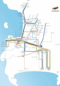
 Cape Town is the most popular tourist destination in South Africa and recognised as one of the most beautiful cities on earth. Public transport is therefore key to sustain the city's role as South Africa's leading holiday destination. The City of Cape Town has therefore decided to implement an extensive Integrated Rapid Transit (IRT) sysatem to alleviate traffic congestion, reduce transport times and stimulate new developments in the Cape metropole.
According to Kylie Hatton, City of Cape Town media manager, the proposed IRT system will include a rail plan, a bus rapid-transit (BRT) system, improvements to conventional bus and minibus operations, cycle ways and bicycle parking, pedestrian and urban space upgrades, metered taxi integration and park-and-ride facilities.
 The IRT project consists of four phases and is expected to take 10 to 15 years to complete. Construction of the first phase has started and is scheduled to be completed in time for the 2010 FIFA Soccer World Cup.
 Phase 1A: Includes airport - city link and city to soccer stadium link
Rest of Phase 1: West Coast link along the R27, including Du Noon, Doornbach, Atlantis and Mamre, will be rolled out in 2010.
Phase 2: Cover areas south east of the city, including Khayelitsha, Mitchell's Plain and the southern suburbs
Phase 3 and 4: Cover northern surburbs e.g. Bellville and Durbanville, the Delft and Blue Downs areas, extending all the way to the Helderberg
Details of phases | Map
This project will undoubtedly cause major traffic disruptions during the construction period and the existing taxi assocations are not happy about the proposed plans but the benefits of an integrated public transport system far outweighs the negative. Roll on IRT!
Related links
Cape Town implements Integrated Rapid Transit (IRT) - Cape Town Partnership PDF brochure
Cape Town's Integrated Rapid Transit site
Cape Town's rapid-transit system begins taking shape - Creamer Media Engineering News
Image source - City of Cape Town


Follow the IRT progress in Cape Town over here too:
ReplyDeletehttp://www.skyscrapercity.com/showthread.php?t=768440